I’ve moved!

Now sharing my thoughts on jocelynesze.wordpress.com instead.

Posted in Uncategorized | Leave a comment

The last of the Greater Patagonian Trail update.

So two months after we completed our expedition hiking down Patagonia, we finally submitted our expedition report to Imperial Exploration Board (just before the deadline heh). If anyone’s interested in doing long hikes in Patagonia (especially on the Chilean side), this could be useful. It’s been a great trip, and while working on the report and going through the photos I took, I realised that although it was not what we had originally intended for it to be, it still had all the elements of it and more. The challenges of finding/making food and making fire and keeping dry/warm were all very real then, if far removed from my reality now, but the memories remain. And I would recommend that everyone does a trip like that once in your life, if you can.

GPT 2016 report

And here’s a visual collection of what we cooked for ourselves during the expedition. While some of it was quite good and nutritious, for half the trip we were eat far less than what we needed.

Posted in Greater Patagonian Trail, Walk | Leave a comment

Part 3: Puerto Ibañez to El Chaltén – Heading south in search of Mount Fitzroy

The Final Leg

This was the section that was tagged on at the last minute; we only decided to go past Puerto Ibañez and hike the section from Villa O’Higgins to El Chaltén when we were at Villa Cerro Castillo. We realised then that because we had planned the onward journey from El Bolsón using the pack-rafting route instead of the hiking route, and the subsequent hitchhiking of sections, we would finish sooner than we intended. We also wanted to go down to Patagonia proper and see Mount Fitzroy, and the hike from Villa O’Higgins to El Chaltén seemed like a good stretch to finish on.

Puerto Ibañez to Villa O’Higgins

To get to Villa O’Higgins from Puerto Ibañez, there was the option of taking the ferry across Lago General Carrera to Chile Chico, and then head south by bus/hitching, or to go back northward to Villa Cerro Castillo and then take the bus/hitch from there. We were told it would be easier to hitch from Villa Cerro Castillo, so back there we went on day 41 of the hike (26 Dec 2016). Hamish had left us the day before, so from Puerto Ibañez, Anne, Omar and I managed to get a ride back up to Villa Cerro Castillo, after a fair amount of waiting time. Hitching from Villa Cerro Castillo onwards (to Puerto Tranquilo) was tough going, and after hours of trying to hide from the blasting wind and sand, we retreated to Puesto Huemul for a coffee. We stayed there for another night, before attempting the next day.

This slideshow requires JavaScript.

After more hours of waiting in the morning (Day 42), having tried various methods such as Omar hiding in the bus stop while Anne and I stuck our thumb out at every passing vehicle, and waving a board with our destination to the drivers, we eventually gave up and took the bus that came (CLP 5000). Puerto Tranquilo on the Lago General Carrera is famed for its marble caves (Capilla de marmol, Catedral de marmol etc.), and as we had not really indulged in any touristy activities so far, we thought we might treat ourselves and go for a tour with Eco Tranquilo (CLP 10,000).

Puerto Tranquilo was the first of the subsequently very many touristy places. On arrival in the fairly small town, we saw a row of booths/stands, all advertising for trips to the Capilla de marmol or for glacier tours. Lots of backpackers standing around, waiting for buses or tours or trying to hitch a ride. We found out from the owner of a completo/cafe that all the tours for the marble caves are at a standard price of CLP 10,000,  who also seemed to double as the town’s information provider. She knew the timings and prices for buses passing through as well. We camped that night at Bella Vista campsite (CLP 5000), which had very good hot showers and an indoor area for campers to cook with (their own) gas stoves.

32083825141_afeecf24cd_k

The provided for gas stove at San Lorenzo 

I woke up the next day (Day 43) feeling generally crap and feverish. While Omar and Anne tried to get a hitch out of Puerto Tranquilo towards Cochrane, I sat slumped beside the post dozing. Little surprise we didn’t manage to get any rides out, but we realised that hitching from south of Villa Cerro Castillo is much harder just because of the higher volume of backpackers trying to hitch as well, and the lower volume of traffic (it was still early in the season). We took the bus when it came around (CLP 6000), which took almost 4-5 hours. We found the campsite San Lorenzo (CLP 4000), whose owner was extremely nice. The kitchen/dining area had two gas stoves for cooking, and he gave us some fresh herbs to add to our food. I slept most of the day, and managed to sleep/sweat away my fever as well, while Omar and Anne went food shopping on arrival in Cochrane.

They had got some bread, cheese and butter, and were looking forward to having some of that for breakfast on Day 44. We woke up to a surprising mystery, with our cheese, bread and butter gone. The pot which stored the cheese and butter was on the floor, but the meat that was also stored in it was still on the table, as well as the pot lid. There was also some leftover butter left lying on the table from previous campers, and that was left untouched. We wondered if perhaps the other campers, a pair of Swedish girls, had eaten our food in the middle of a drunken night, and tried to make it look like dogs had taken them, but they reassured us that they had done no such thing. We did another major food shop in preparation for the higher prices further South. Prices are three times higher in Argentina than Chile, or so we were told. In preparation for the ban on making fires in El Chaltén National Park, we also made some can stoves like the one we used at the bus stop near Elizalde, but an improved version, and obtained some high grade alcohol.

We attempted to hitch out of Cochrane to Villa O’Higgins the next day (Day 45), but the going was slow. We walked a bit out of town before getting a short hitch to a junction, walked another >20km before we got another short hitch, on the back of a pickup amidst some poop, a dead animal, and pots of cooked food to Puente Barrancoso. There we found a pretty decent campsite, if not for the tonnes of mosquitoes.

We had heard from the lady at the tourist office the day before that the bus from Cochrane to Villa O’Higgins leaves at 7am, and with all our luck in hitching so far, thought it might be best to try and catch that bus as it passed us by. It was pouring with rain as we woke up, but the fear of missing the bus was a strong incentive, and we quickly packed up our tent after waking up at 645am and attempted to hide in the bus shelter. It eventually arrived at 845am, though not after we were all soaked to a certain extent. The Carretera Austral is not all road, and there’s a stretch where a water body connects two ends of the road. At Puerto Yungay, where we waited for the municipal ferry to take us across, there’s a little cafe El Peregrines which sells coffee (instant Nescafé, the coffee of the Chileans, but more on that later)/tea for CLP 1000, some sandwiches/cakes/empanadas etc. and various snacks. After a short ride across the river, we got back on the Carretera Austral, and arrived in Villa O’Higgins at 330pm. The El Mosco campsite (CLP 6000) has an excellent reputation, and for good reason. They’ve got really good kitchen facilities, open to both hostel and camp guests. It was New Year’s Eve (Day 46), and we arrived just in time to join the party. We made some stew to share with the rest of the guests, and had lots of wine. Villa O’Higgins is reputed to have one of the best firework displays (in the South of Chile?), and it was pretty good, with a fiesta in the town hall till the wee hours of the morning.

32164315746_86941a92af_k

The village of Villa O’Higgins

New Year’s Day (Day 47) was spent doing not very much at all, mostly cooking/baking and hanging out with the nice people at El Mosco. There are two companies that take people across Lago O’Higgins/Lago San Martin from Villa O’Higgins to Candelaria Mancilla, Robinson Crusoe which is slightly more upmarket and has a bigger ferry, and Las Ruedas which is smaller but cheaper. The lake is notoriously difficult to cross, with bad weather often forcing the ferry services to halt. The week before we arrived, people were apparently stranded on the Candelaria Mancilla side of the lake for 3/4 days (and since there’s not a village there, they also had no food supplies) as the ferries were suspended due to bad weather. There was a Robinson Crusoe ferry guaranteed to leave on this day, but we didn’t want to have to wake up at the crack of dawn to get the ferry nor did we want to pay that much (we had tried our hardest to look for alternative ways to cross the lake but there were none), so we opted to take our chances and hope Las Ruedas would be running two days later.

The second day of the new year (Day 48) did not start out too well, with rain chucking down almost the entire day. If there is one shortcoming of El Mosco, it’d be that they had a policy of not allowing guests to stay past checkout at 10am. It was raining real hard and we had no where to go, and were allowed to stay till noon. We made the most of the extra time and the kitchen facilities we had to cook our lunch and dinner to take away. We took refuge in the village church for most of the rain to pass, before heading to the pier which was 7km away from the village, and found a bit of a grassy patch to pitch our tents.

Villa O’Higgins to El Chaltén

This slideshow requires JavaScript.

Our ferry was due to leave at 8am (Day 49), and as the clocked ticked by and no one appeared, we started getting worried that perhaps the weather forecast was bad and we weren’t going to leave after all. Another passenger was going on the same boat, a 74 year old American named Gary who was on a cycle tour. We eventually did depart a little past 8am, with just the four of us as passengers. They gave out biscuits, which made me very pleased. After two hours on the lake, seeing the snow-topped mountains go by, we arrived at Candelaria Mancilla, and continued on our hike. With a couple of short-cuts (not possible for cyclists, but they’ve got a nice wide gravel path anyway), it didn’t take us long to arrive at the Chilean passport control check point. A police officer whom we had met earlier on the ferry at Puerto Yungay was stationed there, and it was nice to see him again. We continued on the gravel path on the Chilean side before the frontier, where it somewhat abruptly transitioned into a muddy hiking trail on the Argentinian side. There, the going got pretty tough, especially if you’ve got a bike. We met a few cyclists pushing/hauling their bike along the muddy, bumpy, winding trail and across rivers, and we were all just glad that we didn’t have bikes. We made camp with Gary that night, and shared our dinner and had some whisky.

This slideshow requires JavaScript.

The next day (Day 50), we quickly got to the Argentinian passport control and got our passport stamped, before heading to the 16km trail that ran alongside Lago del Desierto. There was the option to pay for a ferry ride across, if anyone would like to. We didn’t even think of it, not having that much money on us and with the whole point of the expedition being to hike, but there was absolutely no sense of regret, for that day’s hike was probably one of the most beautiful in the entire expedition.

It was amazingly sunny, in contrast with the cloudy, rainy previous days, and we had a great view of all the mountains around us and the glaciers too. Mount Fitzroy itself loomed into view whenever we approached a clearing, and it was such an mind-blowing sight, we stopped countless times just to take a few minutes to admire the view. The forest we walked through was home to the Magellanic woodpeckers, and we paused to watch some of them. We even found an access trail to a little rocky beach by the lake in the late afternoon to rest and admire the view of the glacier/mountains. This however was also the end of our wild camping days, as the high volume of traffic meant that everyone had to stay in designated campsites. We camped that night in Estancia Lago del Desierto (got a discount of AP 400 for three, instead of AP 200 pp), which had a nice indoor area that was sheltered from the freezing wind.

This slideshow requires JavaScript.

Our penultimate day of hiking (Day 51) was another rather epic one, though perhaps not quite as much as that day we attempted to cross the pass to Cerro Castillo. Between Lago del Desierto and El Chaltén National Park was a 37km stretch of (pretty bad) road, which we weren’t keen on hiking on (no one really enjoys having a cloud of dust settling over them every time a car drives past, right?), so we tried to hitch to where the trails in the national park start. We had to split up again, since getting rides in threes is extremely hard, and no one seemed to want to pick us up. Anne and I walked for a couple of kilometres before we got picked up by a nice couple on vacation from Tierra del Fuego (which made the weather here at El Chaltén seem tame in comparison), whereas Omar walked 9+km before some kind Canadians finally gave him a ride.

It was raining by this point, as we started our walk towards Mount Fitzroy, by Piedra Blanca trail. It turned out to be fairly hazardous, with lots of rockfalls and a boulder field to cross, and with heavy rain and strong winds, it made for quite an exciting journey. The wind was so strong that at one point all three of us were blown flat on the ground! We managed to get a really close look at the glacier piedra blanca though, amidst the clouds, but it was quite awe-inspiring nonetheless, though we didn’t loiter too long to admire the ‘view’. We got into Poincenot campsite (one of the three free campsites situated within the national park) and quickly set up camp to try and dry/warm ourselves up a bit. Our alcohol can stoves came in really handy and we made ourselves a nice dinner of mash potatoes. The winds were so strong that sand and grit were blown into the tent (despite the fly sheet being zipped up), and we realised why all the other campers around us had huge stones weighing down their tents. And my phone battery died at some point during the walk, but in any case the foul weather did not encourage any photo-taking, hence the lack of photos.

This slideshow requires JavaScript.

Our final day (Day 52) of this expedition to Patagonia involved very little and fairly easy hiking. From Poincenot campsite, it took us less than 3 hours to make our way to El Chaltén town, while enjoying the sights. It was another nice day, with a clear view of  Mount Fitzroy and the other peaks around it. As civilisation loomed nearer, our spirits got higher (and our tummies got hungrier). To celebrate the end of our expedition, we got 12 empanadas from Che Empanada (the nicest and cheapest place to get some good grub; AP 20 each) and met up with Gary again. We stayed at campsite El Cuatro Estaciones (AP 120) which had a decent indoor kitchen, cos we thought we ought to treat ourselves instead of fighting the freezing cold in the outdoor kitchen at the cheapest campsite in town (AP 100).

The end of the expedition

Thus we officially ended our expedition, though we stayed on in the country/vicinity for a while more after. We are all grateful to Imperial College Exploration Board for making the trip possible, and to our family/friends for the support. The trip was nothing but eventful, the scenery way more beautiful than anything I’ve seen before, and looking back on it now, actually feels like a different life. The feeling of having nothing more to do than just walk the whole day while enjoying the outdoors is almost fading in my mind. It is not helped by my recent move back home to Singapore, where the contrast could not be starker. But that’s for another post, another day.

Posted in Greater Patagonian Trail, Walk | Leave a comment

Part 2: El Bolsón to Puerto Ibañez – hitching down the Carretera Austral, Patagonia proper & experiencing English weather

Hitch-hiking long distances

We covered a lot of ground in this middle section, though mostly through hitching. We did very little actual hiking, though we did have one of our most exciting moments on trail. It was also in this section that we realised the map/planned itinerary in our proposal (to Imperial College Exploration Board for the funding) was for a slightly different expedition. We had initially planned to do a hiking/pack-rafting version of the GPT, but decided later on that we didn’t have enough expertise for the water aspects and just stuck to hiking. Forgot to update the trail in the proposal though, which thankfully didn’t cause any major problems.

El Bolsón to Coyhaique

We stayed in El Bolsón for three nights as we tried to figure out our next plan of action while fattening up. We had heard from the German guy we met a few days before that one of the sections was quite difficult to navigate, and so opted to skip that section too. But as we discussed our past experience trying to get food and the much slower pace than expected, we decided that perhaps the best course of action to take would be to hitch the bulk of the distance we were intending to cover and just hike the end bits which would be in Patagonia proper, a different landscape to the one we were in before. Eventually, we decided to hitch from El Bolsón to Coyhaique (the biggest city in Chilean Patagonia), stock up in the supermarket there, then get back on the trail from Puerto Aysén to Puerto Ibañez.

32033676552_9b96b66df7_b

Much rock around El Bolsón, Argentina

While in El Bolsón though, called the hippie city, we did a short hike up the nearby Cerro Amigo (friend hill) with some friends we made at the hostel (La Casa del Arbol). We also took advantage of supermarkets and cooking facilities at the hostel to eat nice meals and fatten up a bit. As nice as it was to be in a hostel (a bed, a solid roof, hot water shower, gas stoves, what more would we want!), we couldn’t stay there for ever, and so on day 24 (9 Dec 2016), we split into pairs and started hitching south, with the intention of regrouping in Coyhaique.

31371576273_8bae084469_b

El Bolsón from up on Cerro Amigo

Argentinians are known to be very proud of their European heritage, and from chatting with people from Buenos Aires in our hostel, we found out that there is some preference of whites over non-whites (not outright discrimination like refusing to serve someone etc, but more of a reluctance of families to accept a non-white marrying in kinda stuff). Given that Hamish and Anne (we had split into pairs cos it’d be easier to hitch that way) got a ride before us (they had initially hung back while Omar and I tried to get a ride out of the city. But after waiting for a pretty long while, they decided to go ahead of us and try their luck. Technically, anyone able to give a lift should see us first, so we get a ride before them), maybe there is more subtle discrimination about.

Here, our stories diverge. Omar and I managed to get to Esquel, a little town 164km south, just as the sun set, taking 4 hitches, including a Chilean truck driver and a young couple with a 2.5 months old baby. Then hitched a ride to Trevelin (a little Welsh settlement in Patagonian Argentina) the next day (D25), struggled to get out of that town, before catching 3 hitches to Futuleufú (Chilean town right across the border), though not without a decent amount of walking. Treated ourselves to a nice dinner at El Rincon de Mamá (salmon a la pobre, CLP12,000) before settling down for the night.

The next day (D26), it rained pretty much the entire time. We took 3 rides to get to Coyhaique from Futuleufú, one with an Argentinan woman building cabañas (vacation cabins) at Lago Locanao, then a German couple who’s been vacationing in Patagonia for the last 5 years to El Pangue, which was along the Carretera Austral (Ruta 7), and finally a pair of twins studying medicine in Santiago, who were extremely nice. We stopped by Puyuhuapi and past the glaciers along the Carretera Austral, finally getting into Coyhaique in the late evening. We had hoped to do a quick hike in Bosque Encantada along the way, but time was running short. We managed to locate Hamish and Anne, staying in Hostal Austral (CLP10,ooo) which was a pre-university converted to hostel in the summer. They managed to arrive in Coyhaique late the night before, having got a few good long rides.

We stocked up on food from the supermarket Unimarc the next day (D27), getting lots of salami and chorizo (which can scarcely be found in the small village ‘supermarkets’), chocolate, peanuts, and brown rice, brown pasta and brown flour. We then took the bus to Puerto Aysén (CLP2200), and realised on arrival that because we had decided on our next plan of action based on our proposal, which was following a pack-rafting route, we had actually made a detour. The hiking trail, as was shown on our Garmin GPS device, is from Coyhaique, but none of us had thought to check the GPS before taking the bus. So we spent a night in Puerto Aysén, before hitching back to Coyhaique the next morning (we thought it was a bus we flagged down but the driver was just super nice and gave us a lift).

Coyhaique to Villa Cerro Castillo 

Finally back on trail (D28), but mostly involved walking on the asphalt road. We managed to cover a lot more ground naturally, and while it’s nice to walk on flat ground and not worry about tripping over roots and rocks, the dust from passing vehicles made it a less pleasant time.

Perhaps one of the more grim days of walking, it was pouring down with continuous rain the entire day (D29). We covered 21km, the most we had walked in any day. I guess we walk more when the weather is shite, cos no one wants to stop and linger for long. As we passed Elizalde, a little village on route, there were bus stops along the road, and we took advantage of the shelter to make pasta for dinner. We had no gas stoves with us, having been making fires to cook every night, but we carried used cans around with us for just such a situation. Some solid fuel tablets in a makeshift can stove, and we managed to whip up some edible grub. A word of caution to everyone out there – putting brown pasta in cold water and waiting for it to heat up enough to cook on a solid fuel stove does not make great dinners. It tasted like we were eating disintegrated semi-cooked brown wheat bits. The sauce was pretty good though, and made it easier for the stodgy mess to go down the throat.

In contrast to the previous day, day 30 was a bit sunnier (with occasional sprinkles). Along with having some coffee (could make a fire cos we slept in an abandoned barn for the night, though it took Omar much effort) and muesli for breakfast, my mood improved and I found it easier to keep up with the other three. I usually lag behind them a fair amount, having found it a struggle to keep with their pace. That didn’t last very long though, and soon I was lagging behind again. Hamish and Anne were soon out of sight, we managed to miss a sign Hamish had created to indicate a turning, and ended up walking an extra 1.5km along Lago Monreal. We soon realised we had lost them when we never caught up with them, and backtracking was way harder, with the wind now in our faces going uphill. Hamish came to find us, and we passed a settler who sold us bread and little fried buns for CLP2000. We eventually got back on trail, and for once found that there were no fences on either side of the trail. As wild as Patagonia is made out to be, lots of it appears to be fenced.

The next day (D31), we experienced real English weather. The day started out pleasant enough, going through a forest, before getting increasingly unpleasant. First a river crossing, then a bog, more forest, scree slopes, a steep rocky scramble, finally flattening out to a plateau. The trail was mostly lost by this point, and we went on following the GPS trail, along a steep side of hill. We trudged along, closely behind each other with Hamish behind me to guard me from falling down when gusts blew, but eventually Omar realised the seriousness of the situation. By this point, not only were our feet wet from crossing the bog, but it had also been raining continuously, with periods of hail, and as we gained altitude, rain became snow and we were rather soaked to the bone. With sleet in our faces and dropping visibility, Omar made the call to back track and find shelter. We dropped some altitude to head towards the tree line, and set up camp there for the night. Not the most comfortable, still being on the hill with roots in the way, but we were out of the gale at least, and could warm up and dry off in our sleeping bags.

When day broke (D32), we discussed over breakfast whether to proceed with the trail or turn back, given that we were unsure of weather and trail conditions. Going on following the GPS would have entailed going down a ravine then back up to cross the mountain pass to get to Villa Cerro Castillo. We had enough food to last one or two days more, three days at a stretch. Despite the strong winds and freezing cold, I was keen on going forward and exploring the possibilities of crossing the mountain pass, as was Omar. Hamish and Anne erred on the side of caution and lack of information, and wanted to back track to the road and hitch to Villa Cerro Castillo. There was no possibility of us splitting up, so we headed back down the plateau to our previous campsite, where we spent almost 6 hours drying everything out over a blazing fire.

Villa Cerro Castillo to Puerto Ibañez

Getting to Villa Cerro Castillo from where we were by road was no easier on day 33, as even on the roads there was barely any traffic. We backtracked about 5km on the road, battling the winds, and stopping to have our quick lunch of, no prizes for guessing, a chapati. As always, when you start eating, a potential ride goes past. Thankfully another came by soon enough and the couple kindly dropped us off along the Carretera Austral, where we could hitch the next ride to Villa Cerro Castillo, since they were heading north back to Coyhaique. Our next ride Daniel, who works for Travel Aysen, brought us down the Carretera Austral to the road that split off leading to Villa Cerro Castillo. While waiting to hitch our next ride, we met a cycle-touring Swiss couple whom we had met earlier in the north of the Carretera Austral, when it was pissing down rain and we were trying to get to Coyhaique. We met them again in Villa Cerro Castillo, and then again in Cochrane – what can we say, Patagonia is small? Just as we managed to flag down another ride, the medical student twins who gave us a ride to Coyhaique passed in the opposite direction, and reversed back to say hi. I suppose when there’s just one major road in this huge expanse, it makes the place seem quite small.
Our next ride, a Chilean guy and his Canadian partner, got us to Villa Cerro Castillo, and were full of interesting information. He apparently lived in Canada for a while, but came back when there were proposals to dam the Río Baker to join in the fight against it. It was a huge controversy – in many places, we saw stickers or signs that said ‘Patagonia Sin Represas‘ (Patagonia Without Dams). From him, we learnt the locals’ perspectives on the environment, the Tompkins’ work on conservation in Patagonia, and the relationships between stakeholders. They worked at the Green Baker Lodge in Puerto Betrand, and Villa Cerro Castillo was on the way. Too soon, we arrived and had to get off. As much as we wanted to practice our Spanish, it was really good and informative meeting people who could speak in English and tell us about the nuances of issues in the area. We came upon cafe Puesto Huemul which offered free wifi, really good food, locally brewed beers and a great view of Cerro Castillo (when there were no clouds). That night, we stayed in a local hospedaje (CLP8000) and stayed up late chatting with the old man whose house it was.
We spent two more nights in Villa Cerro Castillo, though we moved to a campsite El Mirador (CLP4000). Spent some time back in Puesto Huemul utilising the wifi, and the next day (D35) doing a day hike to Laguna Cerro Castillo, about 15km round trip. It was freezing cold and super windy, but amazingly stunning, with the glacier at close view. We figured we could have continued on the hike and made it to Villa Cerro Castillo on foot if we persisted in going up the hill from where we left off, and instead of going down the ravine and up the mountain pass, just continued along the ravine till we reached what we think is Las Horquetas, the start point for a popular 3/4 day hike to Villa Cerro Castillo (it’s in Spanish, but Google Translate exists for a reason).
We eventually left for Puerto Ibañez (D36). Our mistake with the packrafting trail in our proposal meant that instead of a 150km hike to end our trip at Puerto Ibañez, from Coyhaique it was just about 115km or so, and our detour to hitch to Villa Cerro Castillo cut that by even more. The next stretch of hiking from Villa Cerro Castillo to Puerto Ingeniero Ibañez though, was really scenic and pretty. A fairly sunny day for once, we stopped by Museo Escuela and the others went to look at the museum and the Alero de las Manos (wall of hands). I opted to enjoy the view of the mountains, try my hand at sketching and do some journaling. Camping that night by Lago Central was extremely windy and cold, but we were thankful that the Americans who owned the surrounding land had a little shack built, which we could use to hide from the blasting wind.

We got into the next valley on day 37, after a short detour when we went around Lago Tamango/Central (which would have brought us back to Villa Cerro Castillo), and again it was a brilliant, sunny day. I started liking Patagonia a bit more – I initially thought it was just a horribly rainy, windy, and miserable place. There was much less wind in this valley, and a lot of rock all around.

We finally got into Puerto Ibañez (D38), and it being Christmas soon, we decided to spend it there. We stayed at a great campsite, Don Omar camping and hospedaje (CLP3000 + CLP1000 for a hot shower). Basically camping in his backyard, but he also had a little shack with a wood fire stove and electric sockets and toilets for us, and we basically had the place to ourselves.


Christmas at Puerto Ibañez

We spent all of Christmas Eve (D39) preparing dinner. A 2.5kg chicken was cleaned, marinated and put in the gas stove oven by 11am (it took 2.5 hours to make bread the night before – we weren’t sure how long the chicken would take to cook). There was a big cherry tree in the middle of the backyard that was full of cherries, and I happily spent an hour or so picking cherries, using a ladder to get to the higher boughs, and the others pitted the cherries to make some kind of a cherry jam (an attempt to create something like cranberry sauce). Also made some banana chocolate bread (was supposed to be more cake-ish but wells we do what we can with what we have, mainly yeast instead of baking powder). We also cooked potatoes, carrots and onions over the griddle on an open fire (so much oil we were basically deep frying it). After 9 hours, the chicken was finally cooked and we finished it over the fire. It was probably the best meal we had that we cooked for ourselves.  We offered some of the banana bread and cherry jam to Don Omar and his family, and wished them Feliz Navidad, and he was so nice, he gave us a bottle of apple cider in return and invited us to lunch with them the next day. He also told us there was gonna be dancing in the main plaza at 1am, but we either got the time wrong or he remembered it wrong.

This slideshow requires JavaScript.

Christmas day (D40) was an amazingly nice and chill day. I had wanted to go for mass the night before, at 830pm, but didn’t want to delay dinner, so enquired as to mass the next day and was told there was one at 11am. Well there wasn’t one, and we asked one of the shop owners who said it was at 1130am. Neither was there one then – in fact, there usually aren’t priests at that parish, and the guy only comes in once a week. Nonetheless, we had a lovely lunch with Don Omar, his wife Claudia and daughter Cathy, finishing off with a drink of apple cider topped with pineapple sorbet – apparently a classic drink of the area. Googling it now, it appears to be a mix of Chilean and Argentinian culture – Don Omar’s from Buenos Aires (Argentina) while his wife’s from Cochrane (Chile), and they have the sweetest love story ever. He then offered to take us kayaking after lunch, and we paddled around the shores of Lago General Carrera, the second largest lake in South America for a bit, before the strong winds sent us all scurrying back to the campsite for warmth.


Posted in Greater Patagonian Trail, Walk | 1 Comment

Part 1: Coñaripe to El Bolsón – when we came close to starvation and started changing our plans

The start of the expedition

Anne, Hamish, Yousef, Omar, and I left Santiago de Chile for Coñaripe on 16 Nov 2016 on an overnight coach (just called a bus here) at 10pm (cost CLP10,000 each), and arrived the next morning. The long-distance buses are pretty comfortable, if you take a long enough journey they might feed you (more about that later), and they show (Spanish-dubbed) films to keep you entertained. Excitingly enough, about 6am in the morning somewhere along the way, Omar and I were woken up by the police (who were doing a routine search on the bus, I assume?) and asked to step outside for a while with our belongings. It was freezing cold outside, and they searched us and our bags for drugs. I guess we looked like drug smugglers…

Coñaripe to Puerto Fuy

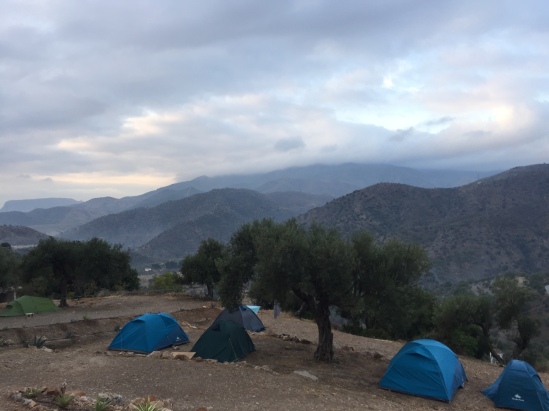
We arrived in Coñaripe (D1), a pretty nondescript town in Los Ríos region of Chile. Volcán Villarica is the main reason why people (local tourists) go there, and there are also hot springs ‘nearby’. After we alighted from the bus, we looked for a cafe to get some coffee and breakfast, as well as a hardware store to get a machete. The lady from the panadería (bakery) was very friendly, a Jehovah’s Witness from Colombia, and told us about visiting Volcán Villarica and some local hot springs that were ‘just 4 km away, past a big bridge’. After acquiring our machete, we headed for these hot springs. And ended up walking 16km along the dusty gravel road, before finally arriving at a hot spring resort, which cost CLP10,000 for entry. That was our first experience of locals giving us wrong information/terribly underestimated distances. We headed towards the lake Pellaifa to set up camp, and passed a smaller hot spring ‘Termas Pellaifa’ which was just CLP3000 per entry. So we spent our first evening soaking in the thermally heated pools (they had one freezing, one luke warm, and one hot water pool). We definitely needed it, having started the hike with some pretty fast and long walking along dusty roads, instead of easing into it. There were a few other travellers in the pool, three Germans on a cycle tour and an American guy doing a work/travel in South America. We later met those Germans again, in Coyhaique (and Anne later met them again in Tierra del Fuego!).

I had also brought some Singapore army ration pack that my mum had acquired from one of her friends, we were so hungry we decided to heat them in the hot water pool and have it as a pre-dinner snack. They are pretty good, I must say. If very heavy and unfeasible to carry on a long-distance hike.

While at Coñaripe, we had also made friends with a little Jack Russell who came along with us the whole way, even to the hot springs. Jackie, as we named her, didn’t even get distracted by other people at the hot springs and followed us back to our campsite. Back at camp, the guys quickly got a fire going and we had a quick dinner of fried rice.

This slideshow requires JavaScript.

To start of our first full day on the hike (D2), we made some chapatis, and after a quick  breakfast of a chapati each topped with a fifth of an avocado, we started back on our hike. Realising that we would have to walk another 20km along the road, we opted to take a bus to the next town of Liquiñe for CLP700. While waiting for the bus, we popped into the fancy hot spring resort restaurant for a coffee, and were super excited and happy when they gave some free rolls to go with. After getting into Liquiñe and having a quick lunch of another chapati each, we took a steep shortcut uphill and got to some sort of timber yard to set up camp, and the usual evening chores of making dinner (rice with peanuts and pepper) and chapatis.

This slideshow requires JavaScript.

Along the trail (D3), we came to a lake, and a house being built right by the lake front. We asked if we could take a quick dip there, as it was hot and spent over 2 hours there having our lunch, a dip, a siesta, and even a bit of fishing. All in all a very chill, lazy day.

This slideshow requires JavaScript.

Having just walked about 6-7km per day the last two days, we doubled our distance covered on the 4th day and got to Puerto Fuy. Along the way though, we came across a bridge that was broken by a huge tree that had fallen right across the middle. And being people who enjoy the moment and clambering over a natural playground, we spent some time there, chasing each other and trying not to fall into the river.

Getting into Puerto Fuy, we got some wine and bought churrascos from a little kiosk as a treat. We headed back along the banks of the Lago Pirihueico to camp, and was told by a guy who drove up that we had to pay CLP8000 per tent. Still not entirely sure if we got cheated or if it actually was on his property, but that was the most expensive and crappy campsite we had to pay for, given that we could barely find firewood to start a fire, and there were no facilities.

This slideshow requires JavaScript.

Puerto Fuy to Puyehue

Yousef had decided to leave us to head back to London (D5), and having heard that the next section was particularly gnarly, with lots of potentially dangerous river crossings (and threats to our lives), we decided to skip it. This group decision came about from a combination of us wanting to enjoy the hike (and not just complete our mission for the sake of), the realisation that the trail terrain and procuring food was tougher than expected, and our desire to reach Patagonia proper. This diversion would require us to bus all the way across Chile to the coastal cities and down the main highway then back across to get back to the trail.

While waiting for the bus, Carla, a German woman who was hiking the GPT on her own (full respect to her!), found us. She started the hike two days ago, and well, quickly and easily managed to catch up, which is not too surprising I guess, considering how we covered just 6km a day. She was hoping to cover the next section with us, but as we had decided to wimp out skip the section, she had to cover it on her own (which she did in a week, hats off to her!).

We ended up taking a bus to Panguipulli (CLP2500), where Yousef left us for Santiago, then to Valdivia (CLP3300), where we found some nondescript bit of land under a bridge to camp for the night. The next day (D6), we took the bus to Orsono (CLP3500), then to Aguas Calientes, Puyehue in the Los Lagos region (CLP2200) and started hiking.

Puyehue (Aguas Calientes) to Cochamó

The hike started off being really muddy and squishy, which perhaps was the start of having wet muddy feet on trail. We had to find our way to rejoin the GPT, and had to go up and down a scree slope (which I did not enjoy; D7). We passed a ski resort/hotel Antillanca, and decided to pop in for (some rather expensive) lunch (but also found wifi!), before finally rejoining the GPT in the midst of some really thick bamboo forest.

The highlight of the next day (D8) was crossing the Río Aguas Malas, the most and only exciting river crossing we did the whole hike. Coming to the bank about noon, I was hungry and started preparing our usual lunch feast of a chapatti and a bit of avocado. The guys, excited at the prospect of a challenge and seeing a boat on the other side of the bank, swam over and tried to scout out the possibilities, before swimming back with a huge log. After a quick snack, we readied our bags for the river crossing, making sure all important items were in dry bags. The water was quite cold, though thankfully the day was blazing hot, but I still squealed my way across as I swam. We then spent the next hour or so drying off in the sun, and I’m glad our dry bags (even those we got on a £2 offer from Podsacs) held up, including Anne’s garbage bag dry bag 😛

We came across a couple selling some basic items in a little shack by the lake Lago Rupanco, and the guy told us there was great fishing in one of the lakes we will be passing through, and he once caught a salmon that was about 80cm long, which got us really excited about our fishing prospects.

Later in the evening, we came across a house that offered the let us stay in their backyard, use their outdoor fireplace to cook, and their bathroom/toilet in on of their cabins for CLP5000 pet tent. We also bought some eggs (CLP2000 for 10) and wine off them, and they were nice enough to offer us some cake they had made. They were starting their hospedaje business, offering cabins to stay.

This slideshow requires JavaScript.

The next day (D9), we chanced upon Laguna Chica, a little lake with lots of reeds about, that we thought might be the one the guy had mentioned earlier. The boys were starving by now, on our diet of two chapatis and rice everyday, and were desperately keen to catch some fish. Eventually, after at least 3 hours, they caught a little trout. Happened to be (American) Thanksgiving as well, we made a fish curry with that little fish, and ended the night in high spirits.

This slideshow requires JavaScript.

We were to arrive at Lago Todos Los Santos at the end of the day (D10), and having stopped by a few local settlers to ask if they sold bread/honey/food (they didn’t, despite signs advertising otherwise) who told us that by walking along the shore for a bit we could get to a hotel and a cafe, we were super excited. In high anticipation for some proper food and coffee, we reached the shore in the evening, only to discover that not only was there no hotel or cafe there, there was also just no one, and no scheduled ferry that departed from that shore. You have to call to arrange transport out. It was starting to piss down rain by this time, and we decided to just set up camp and start cooking while we figured out an escape plan. There was that feel of being stranded on a deserted island, the knowledge that we might be able to find some civilisation about 5 days walk away along the shore didn’t help when we were running low on food. Thankfully enough, as we were preparing dinner (more chapatis cos mash potatoes were insufficient to fill all of us apart from anne up), we heard the distant sound of a motor boat, and the guys sprinted to the shore to try and hail it down, and managed to arrange an escape for us to Petrohúe the next morning.

The motorboat ride to Petrohúe (D11; CLP10,000 each; a diversion from the GPT, but the only arrangement we could get) was freezing cold and took over an hour. We have no idea how that local lady thought it was possible to get there by walking along the shore (granted our Spanish understanding was limited but it isn’t that bad), but we did manage to find the hotel and cafe she talked about. After an expensive but pretty awesome lunch in the hotel (Petrohúe lodge), we tried to get back on trail, taking the bus to Ensenda (CLP1000) then Cochamó (CLP1500). We then had decently priced dinner at La Ollita, the staff of whom probably noticed our hunger and gave us a second serving of free bread.

Cochamó to Segundo Corral

We made friends with an American climber, Nick, at La Ollita the night before, and met him again having breakfast at the same place (D12). Cheekily, we asked for a ride, to save us walking along the road, since we were all heading towards La Junta, where the climbing action is. The road doesn’t go all the way to La Junta though, and we had to hikeabout 13km to La Junta itself, taking about 2-3 hours. Considering it’s lack of accessibility (and lack of shops/food procuring potential), it’s surprising that La Junta/Cochamó still attracts as many climbers as it does. Though I guess climbers are hardly deterred by a long access hike. The rocks there are world-class though, and if access was made easier, it would easily see lots more people. Though apparently in high season (mid Dec to mid Feb/mar?) the few campsites that are there are packed with tents. With no option of wild camping, we stayed at one of the campsites for CLP4000 each.

Despite not having any climbing gear on us, being close to crags and not even touching the rock would be sacrilege, so together with Nick, we tried to find the crags (D13). He had some spare slings, and we managed to fashion some crude harness from it (this should probably have a ‘Do Not Try This At Home Kids warning), and did a climb at La Luna.

Not wanting to stay another night at an expensive campsite (we’re all running out of money by this point), we decided to pack up and move on in the afternoon. The trail from henceforth was very muddy, with lots of alternatives paths of varying dryness, and ditches which horses use. Trying to keep our feet from getting wet was a constant challenge; on one occasion, the guys made a leap across a flooded ditch, which I thought I might be able to accomplish if I threw my bag across first. Which obviously did not happen; it merely landed with a splash below, and I was just thankful it didn’t land on my GPS communicator (InReach Explorer). Combined with two river crossings that required me to take off my socks and shoes to wade across, it was a pretty draining day for me.

This slideshow requires JavaScript.

Day 14 was an exhausting day, with a constant headache, but we met another German hiker also doing the GPT but starting from the south and heading northwards. It was nice chatting and exchanging information on what lay ahead for both our parties, and we got the idea of perhaps supplementing our diet with some granola for breakfast and pasta at night from him.

Most of the day (D15) was spent walking along Lago Vidal Gomez. Everyone was in high spirits after a particularly good breakfast that included leftover rice from yesterday’s dinner, and ‘chowbows’ – a name we made up for chapatis that had rice mixed into the dough. The German guy told us he had a really good asado (barbecue, usually lamb, typical of the Patagonian region) in one of the settlers houses on the further side of the lake, and we were hopeful as we approached. Along the way, we passed another settler who advertised that they were selling food, and for once that was true. For a can of beer, a jar of marmalade, some buns and boiled eggs, we paid CLP12,000. Food ain’t cheap around here. As we arrived at the other end of the lake, we found the settlers whom the German had dined with, but to our dismay they had run out of meat and was not able to provide an asado. We carried on to find a campsite, and for the first and only time in the whole trip, Anne and I made fire while the guys went off to scout for other asado possibilities. That they found, but the settler wanted us to camp on his land as well, and so they politely refused and bought 4 eggs for CLP2000 instead. That’s about £2.35 for 4 eggs, undoubtedly the priciest eggs I’ve had in my life.

Day 16 was filled with lots of uphills and downhills, with a little break in a valley before finishing with a particularly horrible uphill.

By this point (D17), we were once again running low on food and needed to stock up. According to our maps, there was a little place called El Manso where we should be able to get more supplies. Arriving at the first building we saw, Anne was overjoyed to find that despite it being a tiny minishop, it stocked snickers, and everyone (but me) was glad to have some cheese. We then tried to get to El Manso, and found out to our amusement that all there is to El Manso is another mini market about 4km from the other. From there though, we decided we were not keen on hiking along similar landscapes for another few days and decided to speed up our progresss by hitching rides to Llanada Grande, then Segundo Corral which was on the Chilean-Argentinian border. Two guys on a fishing trip picked us up, and after spending a while fishing along río manso, they dropped us off outside one of the two supermarkets in Llanada Grande. That evening, we had one of our nicest dinners of really good sausages (not the hotdogs which are cheaply and commonly sold everywhere in chile as part of their national cuisine, the completo) with pasta and some wine.

We spent most of the next day (D18) loitering outside the other, bigger and more popular supermarket in Llanada Grande, hoping for a hitch to Segundo Corral. Unfortunately, as the (asphalt) road ends slightly before the village, no one really heads that way and we eventually took the bus (CLP3000) to where the road ends, and walked into the village. Tried our best to find the supermarket there, which was strangely elusive, but ended up finding Hospedaje Margo (kinda like a B&B in someone’s house). Margo was the best, served us an amazing lamb ate dinner for just CLP3000 each, and also told us thatt he boat across Río Puelo, which we needed to take to get back on trail, doesn’t run on weekends so we’d have to wait till Monday.

That gave us a lazy Sunday (D19) to spend in the little (but bigger than El Manso!) village of Llanada Grande. We went back to Marco’s for breakfast (CLP2000), and since it started raining, spent the rest of the morning and early afternoon loitering around her house, getting lunch (CLP3000) and some bread (CLP6000 for 20 buns), and picking cherries (so many cherry trees!). She kindly offered her kitchen floor for us to sleep that night as well, but we opted to stay in a refugio that was located closer to the river.

Border crossing: Segundo Corral to El Bolsón, Argentina

The municipal boat to get from Puerto Segundo Corral to Puerto Lago Puelo apparently runs from 8am, and so we got there (D20) for that time and waited for about an hour before the boat arrived to drop off a few school kids. Unexpectedly, as it was municipal, it was a free ride! We quickly got to the carabineros (police in Chile), got our passports stamped, crossed the border into Argentina and then reached the gendarmeria (police in Argentina) to officiate our entry, which were maybe about 11km apart. We found the trail in Argentina (though it was one continuous path) to be much broader, well-kept and signposted than in Chile.

The last day of this section (D21) took us a few hours of hiking to get to Lago Puelo town in Argentina, where we got a bus to El Bolsón (ARS8) to figure out our next plans. By this point, we were still constantly hungry and weren’t sure if we could actually complete the hike as planned (even with the bits of skipping on buses), running out of money and finding that we weren’t keeping very well to the itinerary as our pace was too slow.


More to come – took ages to get all my photos from the trip up on Flickr, but discovering Flickr Uploadr halfway through the trip made my life much easier, but photos from the first half wasn’t uploading properly. Check out the trip album here.

Posted in Greater Patagonian Trail, Walk | Leave a comment

The end of our expedition

We officially ended our expedition on the Greater Patagonian Trail on 6 January at El Chaltén, Argentina. The eventual itinerary we took differed vastly from our plans, we ended up travelling almost 2500km down the length of Chile/Argentina and hiking only about 400km in the 52 days, instead of hiking 1200km in 67 days, but it’s been an amazing, challenging and wonderful trip nonetheless. 

I’m going to be covering this expedition in several posts; one looking at our kit and how they fared, another at the food and cooking aspects (one of the major challenges on trail), and several covering the actual itinerary. 

Monte Fitz Roy, El Chaltén

Posted in Uncategorized | Leave a comment

A month on trail

Quick update cos I don’t particularly enjoy mobile blogging, but we’ve left Santiago de Chile about a month ago now to start the Greater Patagonian Trail, and thought I should perhaps update a bit since I can. 

We’re currently sitting in a quaint cafe in Villa Cerro Castillo called Puesto Huemul (a huemul is an endangered native deer, the South Andean deer Hippocamelus bisulcus) which has wifi, really nice coffee and food (more about Chilean coffee and food in another post). A fair number of cafes and places we’ve been to now have wifi, which is apparently a change from even just 4 years ago when there wasn’t that much connectivity in these parts, according to a German guy who picked us up when we were hitching rides and who’s been coming to Patagonia for the past few years. 

Pretty obvious our plans have changed a fair amount from what we had planned to do. For one, we’re a lot closer to our intended final destination, Puerto Ibañez (~30+km as the crow flies/by road). For another, we’ve actually spent time in places with wifi, when we originally thought we’d just be unconnected till we finished the walk. I’ll write in more detail in other posts about this trip when I’m reunited with my laptop eventually. In brief though, we’ve skipped several sections of our trail. Some cos they’re rather impassable with overgrown or non-existent trails, but overall what we realised was that we were moving a lot slower than we hoped to as the terrain was rougher and because it was hard to procure food, we had to carry food for 6 days and that made our packs quite heavy. As such, we decided to skip out a huge chunk of the middle section as we were all keen on seeing more of Patagonia (we started out north of Patagonia), and hitched our way to Coyhaique, the biggest city in Chilean Patagonia. 

We will probably keep hiking on a bit more past our original intended destination, but plans are always just that I guess, and we’ll just keep making changes. Patagonia is distinctly different to the north though, much windier and colder with mountainous snow-covered peaks and glaciers. Also more expensive; if there’s one thing to note before planning a trip here, always bring/have more money than budgeted. 

Till the next update, have a blessed Christmas, feliz navidad! 

Posted in Greater Patagonian Trail, Walk | Leave a comment

Rekindling natural curiosities

Between my road trip from London to Spain, and me being here in Chile to start the Greater Patagonian Trail, I was with my parents in Italy. They were there for a church pilgrimage tour and conveniently enough I could travel with them for a bit before coming South and before their trip started. I enjoy travelling with them, but this was a particularly poignant trip for me. Having grown up, like me, in a tropical city, they had little chance of experiencing the seasons that many I’ve met over my four years abroad seem to have taken for granted.

fullsizeoutput_3725

I love autumn colours, it’s hard to get a camera to capture all that beauty. View on the way up Pic du Canigou, French Pyrenees.

We took a walk in the park while we were in Milan, and the sycamore seeds were falling. I pointed it out to them, and to my delight they started trying to catch them. My mom then picked up a golden yellow leaf from the ground and commented on its pretty fan shape and brilliant colour. “Ooh that’s a gingko leaf!” And they were so excited to see the trees, and I picked up some fruits that had fallen nearby to show them. Unlike the Brits who I guess, see the trees often enough but don’t really know the gingko ‘nuts’/’seeds’, my parents are very familiar with the edible gametophyte/kernel of the fruit (which we call ‘beh kueh’ in dialect or 白果 ‘bai guo’ or literally white fruit) but not with the trees.

img_4397

Excitement about the gingko tree


Later when we were wandering about Sardinia, the day I had planned to do some nice mountainous walks around the Gennargentu area, we came across a guy picking things off the floor. The actual mountain trail hike we aborted as the weather was as dismal as London’s, and worse, with tropical-sounding strong gusts. We stopped by a little village to get some coffee (and came across a small shop stuffed with random donated knick-knacks and an old lady who convinced us to give an euro for a chance to win something from the lottery draw. We gave two euros and got a little nativity scene wood carving and a McDonald’s wind-up sea creature-of-sorts, I couldn’t tell if it was a seal or a sea lion…). The torrent abated for a bit to a slight trickle, and there was a sign that said ‘Fuente’ and pointed uphill. I told my parents there was a fountain up there and if they’d like to see it. So up we wandered, found a little pipe coming out of the wall with water gushing. Snapped a photo, as always, and continued our way up. After a while, my mum asked where the fountain was, and I said that pipe was it, which considerably disappointed her. Nonetheless, we continued our way up until the path and rain became fairly perilous, and headed back down. As we neared the car, we came across an old man picking things up from the ground and putting it in a bag. I thought perhaps litter or something, but as we came closer, he showed us these nuts he was collecting. Walnuts, all over the ground! My parents were super excited, and my mom joined in picking some of them, with encouragement from him.

Those are the moments that make me really happy, to be able to share with them the joy of being in nature and being closer to nature. To let them know the trees whose fruits they’ve been consuming for years. It’s a child-like wonderment and curiosity at the natural world, something innate that we all have inside us – something like EO Wilson’s biophilia. Despite being city folks, they didn’t grow up with nature deficit disorder or suffered the extinction of experience. During their childhood, Singapore was still a much wilder place, kampongs and chickens running around were widespread, and my mom always told us about how when she was younger she had to help stuff kapok from the kapok tree into sofas that her parents made. My generation didn’t get to experience much of that, but our childhood still consisted of a fair amount of outdoor play. The current generation’s childhood though, is almost completely devoid of anything natural (beyond perhaps urban pigeons and mosquitoes)*. Yet the wonderment and awe that we all feel when we encounter the natural world (from reactions to the latest Planet Earth II release to the emotive posts that accompany photos of mountains/oceans/lightning storms etc.) is something that is hardwired in us, and squashing it out of people’s lives (from overly urban living) is probably one of the greatest losses in modern day living.

img_4449

And the chance to build cairns.

*Yet Singapore is much wilder than it seems, and kids these days do seem to have an ‘outdoor education’ component in the required syllabus. Maybe it’s just that everything seems a bit too structured and manicured.

P.S. This post is also scheduled to space out the publishing of posts. I’m currently on my 67 day hike and you can see our progress here.

Posted in Natural history, Walk | Tagged , , , | Leave a comment

Sport-climbing in El Chorro

Where I did my first proper multi-pitch and attempted to use a shewee (pee funnel for women) to hilarious results.

The last blog-worthy bit of my road trip from London to Spain is sport-climbing in El Chorro, Malaga. El Chorro was a place I’d always wanted to go to climb, since I came to the UK four years ago. Happily enough, my road trip buddy’s parents lived close to Malaga, and so we could end the trip with some nice climbing. We stayed at the Olive Branch (€8pppn) while we were there, which was slightly above the village.

img_4328

Olive Branch campsite.

The weather was forecasted to be very rainy while we were there, but the weather held up enough for us to do a few climbs. I had never really done a complete multi-pitch climb before, the most I had ever done was two pitches of a much longer climb. So I was really psyched to do a nice long but easy eight pitch climb called Amptrax.

img_4331

The Frontales crag where Amptrax is.

The approach to the start point involved a bit of a dodgy down scramble cos we veered a bit to far right. The first pitch was basically a walk/scramble up, but the rest of the pitches were quite fun. The sixth pitch was a right traverse, which I was leading and was slightly nervy in my opinion, had to do some really far-out leaning to my right. Probably also went off route cos there were points when I had nothing much to hold…

Nonetheless, it was definitely the highlight of El Chorro for me and the most exciting bit is possibly my attempt to use the shewee while in a harness on a wall. I bought the shewee five years ago when I was climbing Island Peak, and had only used it once on that trip – to pee into a bottle when we were in high camp while in the tent because I was too cold to go out and pee. Being in a harness makes using a shewee much much harder. I basically wet myself on the wall :X I’d advise anyone who’s intending to use one to practise first before going out. Thankfully there wasn’t anyone else around who saw me using it anyway 😛

I’ve written before about the appeal of climbing, but I missed out a major point in that post. That feeling of being to go somewhere that few others can, and the view from the top of a climb.

img_4356

View from the top of Amptrax.

Was a pretty good end to the 3-week long road trip. Would have been nice to do a few more multi-pitches or harder climbs but the weather turned and got very rainy. So yeah, Amptrax was my main highlight and the limestone in El Chorro is really nice 🙂

P.S. This is a scheduled post to space out my posting. I’m currently on my 67 day hike and you can see our current location here.

Posted in Outdoor activities | Tagged , | Leave a comment

Off to Coñaripe to start!

Sooo, we’re all packed and the bus tickets to Coñaripe have been bought and we’re almost  ready to go 😀 Santiago is a pretty cool city, a mix of modernity and the less-modern. I’m out of words to describe emotions, and also in a rush, so shall just leave with a photo of us in the hostel we stayed in.

All ready to go :D L-R: Yousef (Omar's brother), Anne, Hamish, Omar, and Jocelyne

All ready to go 😀 L-R: Yousef (Omar’s brother), Anne, Hamish, Omar, and Jocelyne

You can see our progress on this online map here, when we start tracking our location tomorrow.

Sunset from Cerro San Cristobal, Santiago, Chile

Sunset from Cerro San Cristobal, Santiago, Chile

Until next year!

Posted in Greater Patagonian Trail, Outdoor activities, Walk | Leave a comment